01
Bluetooth Low Energy
ESTRON BLE
Direct control from your phone.
- 2 valve outputs
- Direct control via iOS & Android app
- No wiring required
- Waterproof
Estron's smart irrigation systems let you remotely control the irrigation of gardens, parks, and large landscape areas. Use Bluetooth from your phone at close range, and manage wide areas through a single web panel via GSM, NB-IoT, and LoRa.
Chosen by municipalities, landscape professionals and agricultural businesses across diverse climates.
91% of municipalities irrigate their landscape areas with mains water.
From small gardens to large landscape projects — the ESTRON solution that fits your needs.
Direct control from your phone.
(GSM · NB-IoT)
Long-range network for wide areas.
Walking to every valve is no longer the only option. With the Estron Landscape Irrigation app, get within 10 meters of a valve, tap, and irrigation starts — or leave it to our AI: it analyzes the weather, soil moisture, and plant health, and decides for you.
Penman-Monteith scientific formula + LLM natural language processing. Write in plain language, the system follows it:
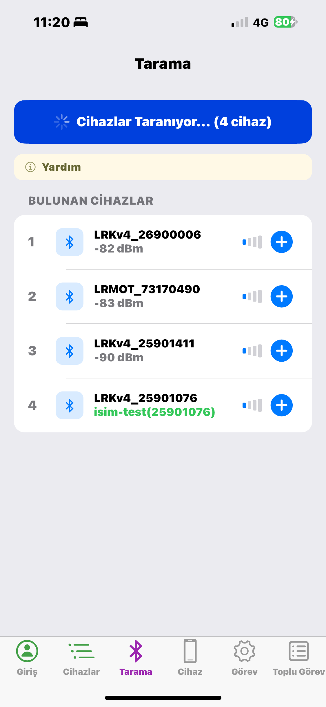
No internet required. Within 10 meters of a valve, the app scans, lists, and connects with a tap.
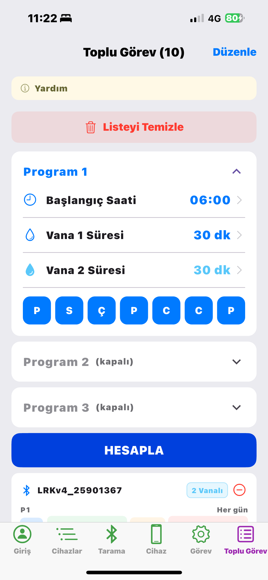
5 devices on the "Front Yard" line, 8 devices on the "Garden Fence" line — push a program with a single tap.
January 0%, July 150%, August 160% — separate irrigation intensity for each month, automatically adjusted by season.
6-digit passcode + AES-128 ECB encrypted authentication. Unauthorized access is blocked.
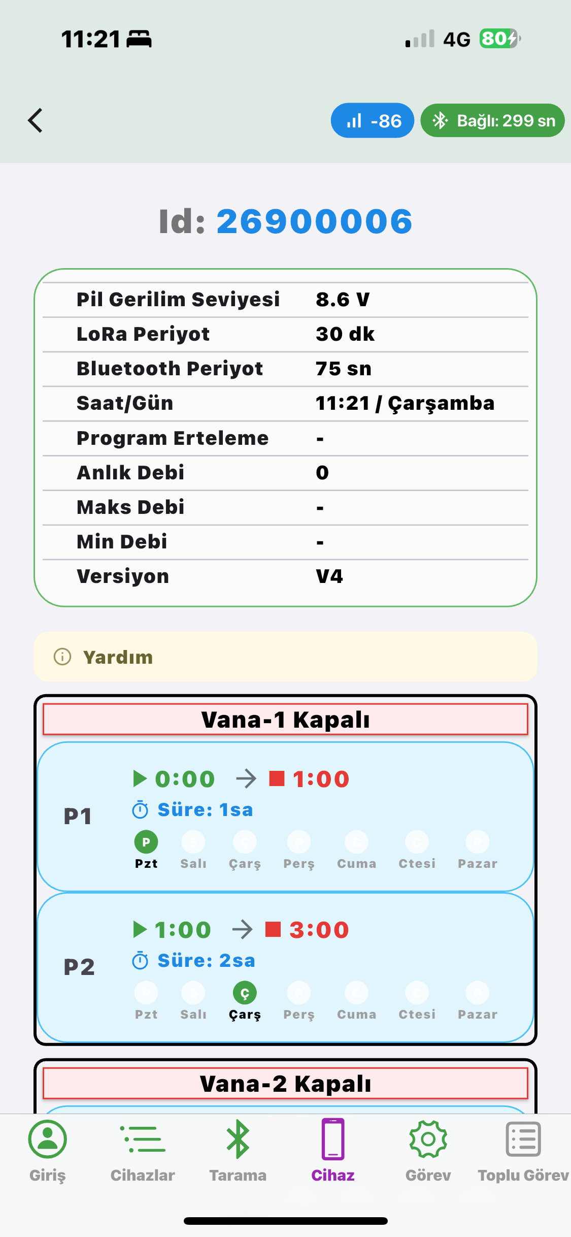
Bluetooth in the field, LoRaWAN from the office — same valve, two channels.
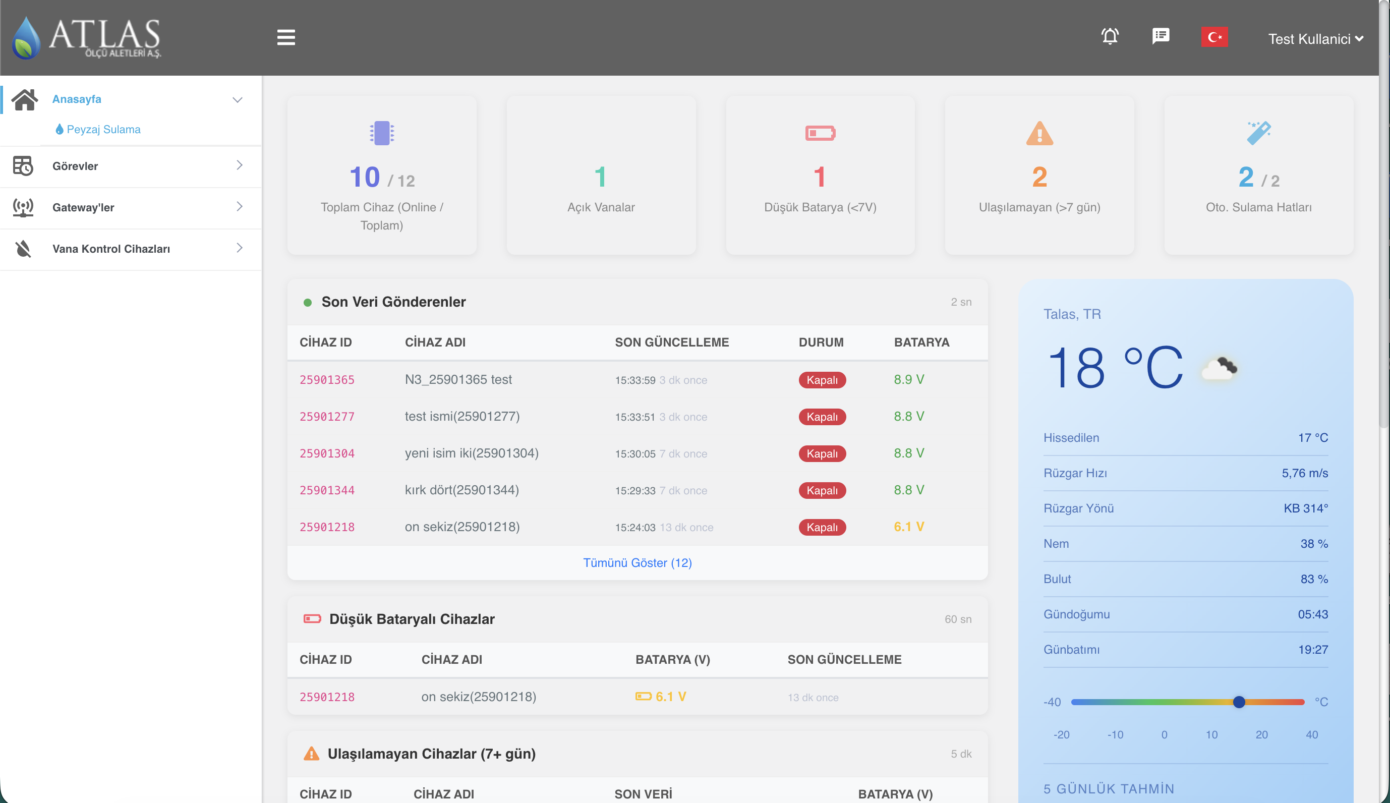
peyzaj.estron — manage thousands of valves from a single panel, in real time. AI decisions powered by the FAO-56 Penman-Monteith formula, Sentinel-2 satellite data, and large language models optimize the entire field for you.
Real-time status of every device, battery level, gateway info.
OpenStreetMap + Esri satellite layers. Valves are color-coded by location and status.
Weather + NDVI + soil moisture + 7-day rainfall history → scientific irrigation recommendation.
NDVI, EVI, NDWI, moisture index — 20+ analysis layers. Historical temperature data from 2017 to today.
Company → Main Group → Sub-Group hierarchy. Drag-and-drop reorganization, polygon definition.
Rain, soil moisture, temperature, conductivity. Irrigation is automatically postponed when it rains.
Separate percentage for each of 12 months (0%–200%). When AI is not used, it is applied as a coefficient to the reference irrigation duration.
All devices, irrigation programs, and decision history — export to Excel with a single click.
Real-time satellite observations on one side, scientific formulas and a natural-language decision engine on the other.
Satellite, weather, scientific formulas, field history, and your natural-language instructions — all delivered to the AI in a single data package.
"location": {
  "latitude": 37.8741,
  "longitude": 30.849,
  "elevation_m": 916
},
"crop_type": "Turfgrass",
"irrigation_method": "Sprinkler",

"weather_forecast": {
  "temp_avg_C": 14.1,
  "temp_min_C": 7.5,
  "temp_max_C": 19.2,
  "relative_humidity_pct": 62,
  "wind_speed_ms": 2.4,
  "solar_radiation_MJm2day": 37.88,
  "rain_probability_pct": 77,
  "rain_amount_mm": 2.4
},

"penman_monteith": {
  "reference_ET0_mmday": 8.25,
  "reference_ETc_mmday": 7.02,
  "tomorrow_ET0_mmday": 4.67,
  "penman_recommendation_min": 8
},

"ndvi": {
  "value": 0.05,
  "Kc_NDVI": 0.4
},

"soil_moisture": {
  "0-1 cm":   "24%",
  "1-3 cm":   "24%",
  "3-9 cm":   "25%",
  "9-27 cm":  "27%",
  "27-81 cm": "31%"
},

"last_7_days_rainfall_mm": 16.4,
"instruction": "skip irrigation if rain is expected"
The AI returns its calculation, interpretation, and final decision as a structured document. Every item is auditable, logged, and line-specific.
24–31% across all depths — sufficient. After 14 mm of effective rainfall on April 23, the soil's water-holding capacity is in good shape.
Today ET₀ 8.25, ETc 7.02 mm/day. With cloud cover and rainfall tomorrow, ET₀ drops to 4.67 — the need is decreasing.
Critical point: 77% probability of 2.4 mm rainfall tomorrow. The user's instruction is clear: "skip irrigation if rain is expected".
NDVI 0.05 is low, but normal for turfgrass in early April — not water stress, but seasonal dormancy.
No frost risk (14.1°C), wind 2.4 m/s — irrigation would have been possible; however, the rainfall criterion requires postponement.
Soil moisture is sufficient, rainfall is highly likely tomorrow, the user's instruction is clear. Irrigation postponed. The situation will be reassessed after the rainfall.
Every decision is logged with its rationale — which day, which line, why. Fully auditable.
Each line has its own AI instruction and its own decision history. One line's decision does not affect another.
Switch to manual mode with one tap. Edit AI instructions whenever you wish.
Irrigation duration limits, frost and saturation checks — no harmful decisions are produced.
From the cloud to the valve solenoid — end-to-end engineering, made locally.
peyzaj.estron.com.tr
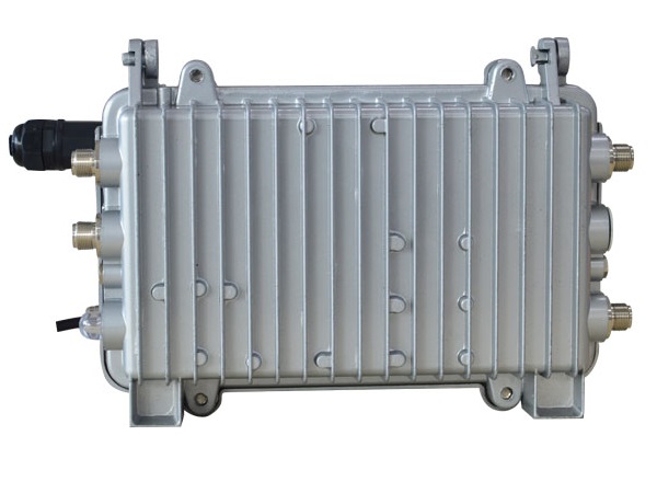
Gateway ATL413LW · LoRaWAN Class A/B
LRK 1-2 · 7 × 5 × 5 cm · IP67
Up to 40% water and energy savings with sensor-based irrigation.
How much water did each zone receive? Full history and charts in your web panel.
Irrigation is automatically canceled when rain is forecast. Smart decisions, zero waste.
End-to-end encrypted data transmission, user authorization, auditable command log. The device is encrypted; if stolen, it cannot be used.
Define custom rules based on time, day, sensor value, or weather conditions.
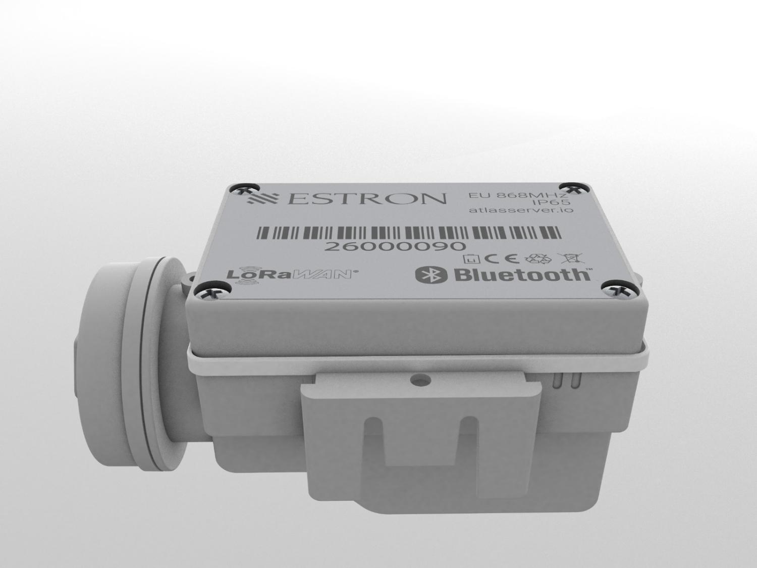
IP67 valve control board, IP68 gateway, outdoor durability rated for −20 / +85 °C.
Runs on 2 × 9V batteries, no wiring required. Adjustable communication intervals let you extend battery life as needed.
Rain, humidity, temperature, pressure, flow (m³/h) and water-level sensors integrate seamlessly with the system.
Thanks to built-in memory, the device picks up the last program right where it left off, even if the connection drops.
Flow values are continuously monitored; valve leaks or pipeline faults are identified in the web panel without a site visit.
Estron devices use the industry-standard LoRaWAN protocol — they can also be managed with any LoRaWAN gateway you already own or prefer.
For enterprises, the system can be managed from your own server; integration with existing SCADA systems is supported.
Irrigation programs prepared on a mobile phone are dispatched sequentially over BLE as the operator approaches each device in the field; the device's clock is also updated at the same time. No need to connect to each unit one by one.
LoRa reaches up to 10 km in open terrain; in cities, buildings, concrete, and metal structures attenuate the signal, dropping the typical range to 1–2 km. Coverage is extended via rooftop placement or multiple gateways; LoRaWAN's star topology delivers reliable communication even in dense urban areas.
The Sentinel-2 satellite pair scans Türkiye every 5 days; 10 m-resolution NDVI imagery is used for plant health and irrigation decisions.
The Sentinel-2 satellite measures near-infrared (NIR) and short-wave infrared (SWIR) bands; the difference between them (NDWI) reveals the water content of vegetation and the surface.
The Sentinel-2 satellite measures red (Red) and near-infrared (NIR) bands; the difference between them (NDVI) numerically expresses the density of vegetation cover and photosynthetic activity.
When a fault is detected at a valve, the technician only needs a phone to head out; using Bluetooth and location data, the app guides the user directly to the relevant valve. No more searching for a faulty device in vast landscape areas.
Let's find the best solution for your project together.